Drones have been relatively trendy recently, and there’s no denying this fact, as drones are now used in numerous areas of human exertion.
If you want to be cooler than usual and have the ability to catch flying objects, we suggest you explore the article about the best drone detection apps.
Moreover, in addition, you can check out our article about the best Polaroid VR apps.
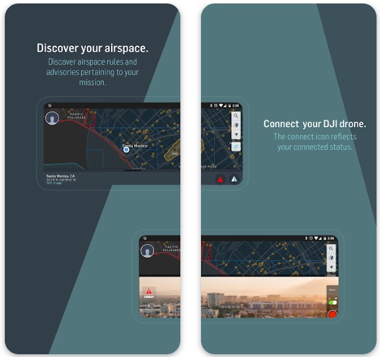
AirMap For Drones
This list is headed by the AirMap for drones app. This app by itself is popular among network users, as it is multifunctional and an excellent helper while controlling drones. So let’s stop beating around the bush and start the review.
The concept of the app consists of three important functions, and these are discover, connect, and manage.
One of the best features of this app is its displaying of drones on the map. Undoubtfully, you will see all the drones which are at least in your city. You can click on any drone and detect its location. see the other data about it.
The interface design is quite straightforward. A convenient and user-friendly interface allows users, not to be confused about where to find this or that function of the app.
While the drone is flying, you can switch cameras through the app, and adjust the altitude or duration of the flight.
For better control and use of the app, you can create your profile and specify the data you want, and configure the control. These are some of the main features of the app, but you can download it and view other options.
Downloads: 500 000+
Customers rating:  (3.4 / 5)

You may also like: 15 Best VR apps for Android
Dronelink
The following app contains similar features and settings that make your drone control much easier.
It has several features and one of the main ones is mission planning and viewing at a full 360 degrees.
The app synchronizes with the satellites maps and can show you the locations of other drones.
Mission layout means that during a drone flight, you can not only view objects from the map as a drawing, but you can view its three-dimensional layout.
On the built-in map, you can select certain locations and make markings there, so that you don’t get lost on the route.
Viewing the layout of objects helps to keep the correct course and altitude during flight, which is very helpful for those who have just started to control drones, and don’t yet know how to keep altitude and so on.
Another feature of the app, it has its own community, which allows all active users of the application to work together and mark places on a common map. With the same account, you can log in from different devices and combine drones.

Downloads: 50 000+
Customers rating:  (3.5 / 5)
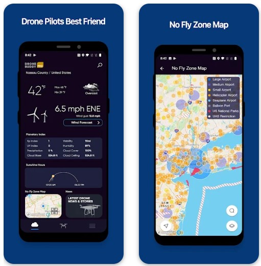
Drone Buddy
The Drone Buddy is also a multifunctional assistant for aircraft owners. It has great functionality that is not available in other apps.
One of the most prominent advantages of Drone Buddy is that it detects all the drones on any spot on the map that you want.
Its main distinguishing feature is the ability to detect wind speed and general weather conditions. Before you start to fly the drone, or during the flight, you can observe how the weather changes at a certain altitude and how it will be reflected in the drone’s flight.
The following functions and features of the application are almost analogous to the aforementioned programs.
For example, the map in it shows not only the places where you can launch drones, but also shows what place in the airspace is occupied by other aircraft. Users can change the map display in the settings.
Another cool feature of the program is that here you can view news regarding flying machines such as drones. If you are a drone enthusiast, you will surely be looking for news and reading about the latest developments in this technology.
To do this you do not need to look for anything, the application has current news about drones in the “News section”. Other settings can also be made at your discretion and wishes, in a word, you can customize the application for yourself.
Downloads: 100 000+
Customers rating:  (4.5 / 5)
Drone help Forecast for UAV
This app has the same properties and settings, and they are even similar in some ways.
In the tools of the app, you can find a special map, which shows the unmanned areas to launch your drone. This feature is very helpful to find the right zone to control the aircraft.
The next feature of the app is a section for viewing weather conditions. The advantage of this feature is that it shows you the weather conditions three days in go, so you can plan your activity a few days in advance.
You can also find out the wind speed and the humidity in the air. In short, users can view information that might be useful for launching the drone in one way or another.
Downloads: 10 000+
Customers rating:  (4.4 / 5)
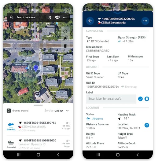
Dronfinder
We couldn’t stay away from mentioning the most crucial apps for detecting drones.
The first and most important of course is the drone detecting function and the erected-in chart.
One main difference between this app and the previous ones is that it’s developed strictly for those who want to detect drones without controlling them.
The app’s chart is point-rich and can show the route layout of your drone, as well as areas where drones can not be launched.
Another advantage of the Dronfinder app is that it can not only find a drone but also detect its model. The app works using the WiFi protocol.
Downloads: 50 000+
Customers rating:  (4.1 / 5)
You may also like: 12 Free VR Games For Android Without Controller
Drone Scanner
This app is fairly new and not that popular among drone enthusiasts. Nevertheless, we decided to write about its functions and features, in case someone likes it and decides to try it. So, let’s first look at similar features, such as a map for surveillance.
The feature of the application, that caught our attention is the “Area Reports” section. In this section, you can find not only data about the weather but also other information concerning airspace and other staff.
It is also worth mentioning, the dynamic safety indicator, which noticeably controls the drone during flight. In short, these are all the functions of the application that we have had time to figure out, but if you want to check it out, you are free to do so.
Downloads: 5 000+
Litchi for DJI Drones
The application has fast and enhanced functionality, and built-in tools that are sure to prove useful during flight launches.
The app allows you to focus on an object while the aircraft is flying. That is, on the screen, users can adjust the display and view in a circle, both from above and at the level of this object.
Operation through the app is so easy that you can make an orbital rotation around the object to view it from any angle. And if you want the drone to follow you and record video, this can also be configured in the app.
The drone’s map and display differ from the previous ones in that, you can see a virtual map on the main screen and an image from the drone’s camera on the corner of the screen.
On the map, you can make marks and adjust the desired routes of the drone. In short, the capabilities of the app are at a high level, which is why it is popular among users.

Downloads: 100 000+
Customers rating: (4.5 / 5)
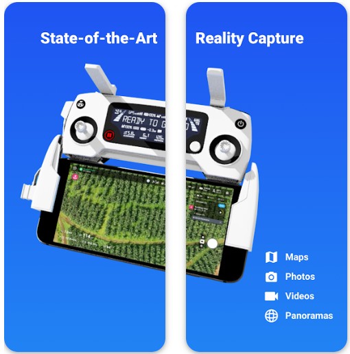
DroneDeploy- Mapping for DJI
The penultimate app on our list is not only a handy drone tracker but also a great way to learn more about the features of controlling aircraft.
The app has four main functions, which are map tracking, photos, and lastly, panoramic display. For easy management of the application, you can configure it with one click in the settings section.
Here users can easily control and monitor the condition of their aircraft. The virtual map makes it easy to keep track of the drone and create a special route on it. The interface of the app is very user-friendly and organized in the right way.
That is, all the tools you need when controlling a drone are located on the right side of the screen, while the left side displays the location of the drone.
Downloads: 500 000+
Customers rating:  (3.3 / 5)
You may also like: 15 Best HD shooter games for Android
Drone Radar
We have to tell you at the very beginning that we’re not sure about the functionality of this app, but the developers claim that you will be enabled to view the drones on your map.
The app has a downloaded map, making it easy to track and locate the drone. In the settings, you can select one of several map display options, for your convenience.
The map in the application has two functions: the first is to view the route of the drone, and the second is to view unmanned areas, where you cannot launch aircraft.
The next thing you should pay attention to is its fairly simple and understandable interface. Each of the functions and sections is in the tank menu of the app.
In general, this app is super simple. This will be more suitable for unprofessional use and just for fun.

Downloads: 50 000+
Customers rating:  (3.2 / 5)